Inicio
Página principal.
Foros
Lugar para opinar y debatir.
Biblioteca
Biblioteca de los Mitos de Cthulhu.
Literatura
Volúmenes de literatura de los Mitos.
Obras
Relatos recogidos en la biblioteca.
Rol
Volúmenes de juegos de rol de los Mitos.
Obras
Obras de rol recogidas en la biblioteca.
Arte
Cómic e ilustración.
Obras
Obras de arte recogidas en la biblioteca.
Ensayo
Volúmenes de ensayo y análisis.
Obras
Obras de ensayo recogidas en la biblioteca.
Cine
Películas y cortos de temática lovecraftiana.
Videojuegos
Videojuegos de temática lovecraftiana.
Juegos de mesa
Juegos de mesa y de cartas de temática lovecraftiana.
Música
Álbumes de música isnpirados en los Mitos de Cthulhu.
Referencia
Elige una sección.
Club de Lectura
Apúntate a la lectura no euclidiana.
Críticas
Análisis de suplementos de rol.
Legado Inforol
Antiguo foro de Cthulhu en Inforol.
Noticias
Ponte al día de las novedades lovecraftianas.
Partidas
Partidas que organizan usuarios de Leyenda.net
Podcast
Una especie de programa de radio sobre los Mitos.
Reportajes
Reportajes y entrevistas sobre temas cthulhoideos.
Ayudas de juego
Elige una sección.
Ambientaciones
Ambientaciones de juego cthulhoideo.
CthulhuTech
Juego de rol futurista que mezcla manga y horrores lovecraftianos.
End Time
Ambientación en un futuro apocalíptico.
Némesis
Sistema de juego para DG y similares.
Ampliaciones
Elige una sección.
Historia
Historia y los Mitos de Cthulhu.
Europa en los años 20
Los Mitos de Cthulhu en la vieja Europa.
Módulos
Escenarios para JdR lovecraftianos.
Navegación
Elige una funcionalidad.
Árbol de artículos
Vadear por todos los artículos de la web.
Descargas
Acceso directo a las descargas.
Enlaces
Enlaces de interés.
Estadísticas
Datos de la web por meses.
Etiquetas
Tags, marcadores, como quieras llamarlos.
Lovecraftian PotD
Enlaces a imágenes lovecraftianas.
Participantes
Lista de usuarios inscritos.
Iniciar sesión
Nuevo
Rol
Imágenes
Literatura
Rol
Arte
Ensayo
Cine
Videojuegos
Juegos
Música
Cualquier idioma
Alemán
Asturiano
Catalán
Checo
Chino
Coreano
Español
Euskera
Finlandés
Francés
Gallego
Holandés
Húngaro
Inglés
Italiano
Japonés
Latín
Noruego
Polaco
Portugués
Ruso
Sueco
«
‹
Página 3/5
›
»
CSV
▲
Título
▼
≋
A
B
C
D
E
F
G
H
I
J
K
L
M
N
O
P
Q
R
S
T
U
V
W
X
Y
Z
▲
Original
▼
≋
Originales
Derivados
▲
Año
▼
≋
¿?
SXIX
SXX
SXXI
Idioma
△
C
▼
⊗
Reglas
Escenario
Guía
Pantalla
Mapa
Hoja de personaje
Apoyo de escenario
Ayuda de juego
≋
La Llamada de Cthulhu
El Rastro de Cthulhu
Cthulhu D20
CthulhuTech
Cthulhu D100
De Profundis
Cultos Innombrables
Delta Green
D&D
Otros
Genérico
▲
V
▼
A
ustralia Map (1910, Foldout)
1987
Inglés
—
A
ustria map in 1920
1983
Inglés
—
The
B
ritish Empire
1988
Inglés
—
C
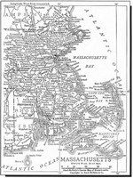
arte: Massachussets, Rhode Island
R
and-McNally's Concise Map of Massachusetts
1990
Francés
—
C
hamber of Commerce Map
1990
Inglés
—
The
C
ity of London (1890s Fold-Out map)
1986
Inglés
—
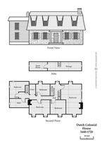
C
olonial Era Houses (1640-1770)
2008
Inglés
—
C
olonial Era Houses (1640-1770)
2009
Inglés
—
C
olour Fold-Out Orient Express Route Map
2013
Inglés
—
C
ommercial Chart of The World (1890s)
2012
Inglés
—
Las
c
onstelaciones del sur
The
S
outhern Sky
1995
Español
—
C
ook's Map of Nile
1912
Inglés
—
The
C
ounty of London (1890s)
1988
Inglés
—
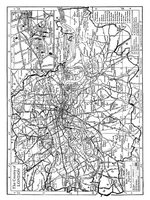
D
unwich Map in 1920
2002
Inglés
—
E
arly 20th Century (1900-1930)
2008
Inglés
—
E
arly 20th Century (1900-1930)
2009
Inglés
—
E
astern Front, October 1942
2014
Inglés
—
E
gipto y el Valle del Nilo
E
gypt & the Nile Valley
2001
Español
—
E
gypt & the Nile Valley
1995
Inglés
—
E
urope 1815-1910
1988
Inglés
—
F
loorplans & Colour Plates
2010
Inglés
—
I
nnsmouth & Environs
1998
Inglés
—
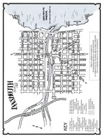
I
nnsmouth Map
1985
Inglés
—
I
nnsmouth y alrededores
I
nnsmouth & Environs
1999
Español
—
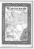
K
enya Political Map 1930s
2007
Inglés
—
△